Welcome to my natural hazards blog! I post regularly about any natural hazards going on around the world on a day-to-day basis.
Enjoy!!
A
Saturday, 12 December 2015
Idaho Earthquakes
More than 40 small earthquakes have been recorded in East-Central Idaho this week (Monday 7th- Sunday 13th December). Experts say this is another earthquake swarm in the region.The earthquakes started on Tuesday and have mostly gone unnoticed or unreported in an area experienced with more vigorous shaking.
However, officials in the Challis area reported no damage from the micro-earthquakes on Friday 11th December 2015.
The earthquakes ranged up to 2.9 magnitude, and scientists are trying to find the fault system in the area, where a 5.0 magnitude earthquake struck in January.
William Phillips, a research geologists from the University of Idaho says scientists are not sure if these earthquakes and tremors could lead to something bigger.
Mount Etna eruption
The world's most active volcano has erupted after two years. The eruption lit up the night sky over much of eastern Sicily late on Saturday night and into the early hours of Sunday. It has been erupting for four days, with lava flowing down the side of the mountain, and hot ash clouds being spewed into the air.
The plume of ash rising from Mount Etna can be seen across much of eastern Sicily.The nearby Catania airport has now been reopened after it closed on Friday when ash clouds caused safety concerns.
Mount Etna is Europe's tallest active volcano, and is located in Sicily. It has erupted many times during history and is still active. Italian authorities have used explosives, concrete dams and ditches to divert the lava flow from the surrounding settlements. However, the latest lava flow did not endanger any houses, and no evacuation was ordered.
Wednesday, 9 December 2015
Storm Desmond
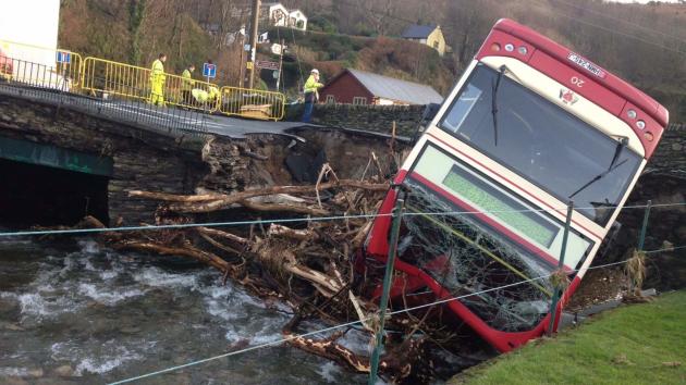
In Cumbria and Lancashire more than 43,000 homes are suffering from power cuts, while an estimated 5,200 homes have been affected by flooding. The storm claimed 2 lives; one in Cumbria, and one in the Northern Republic of Ireland. 5.9 inches of rain poured down in only 30 hours. Bridges collapsed, 40 schools were closed, and the government issued 15 severe flood warnings across the country.
Storm Desmond flooded parts of Northern Ireland, north Wales, Southern Scotland and especially North-west England over the weekend, and more heavy rain is expected this week.
Record-breaking amounts of rain fell in Cumbria, the worst-hit county. Many criticised the government after the multi-million flood protection that they installed in Cumbria in 2005 failed to prevent further disasters from happening.
8 rescue centres were opened to the public and life boat crews and military personnel were dispatched.
Developments:
Electricity North West said power had been restored to 1,200 customers in Cumbria, however more than 1,450 remain without power.
Why is the UK getting hit by severe storms and flooding?
Storm winds bring warm water across from the Atlantic Ocean. These waters start to form a storm, as a result of high temperature waters, the Coriolis effect, and condensation. The storm moves over the warm waters, collecting water vapour, and causes devastation when it hits land.
Friday, 4 December 2015
Hurricane Sandra
On Monday 23rd November Hurricane Sandra hit the southern Gulf of California. On its journey North, it was close enough to drop more than 2 feet of rainfall along part of the coast of Western Mexico. However, Sandra remained well off the western Mexican coast during the most dangerous period, November 25-27, 2015. It was a very powerful hurricane with sustained winds of up to 130 knots, or 150 mph.
An analysis created by NASA's Goddard Space Flight Centre in Greenbelt, Maryland showed that much of Sandra's rainfall occurred over the open waters of the Eastern Pacific Ocean. The analysis also shows moisture flowing from Hurricane Sandra also caused heavy rainfall totals of over 700 mm (28 inches) in an area northeast of Puerto Vallarta, in Mexico.
On Thursday morning, 26th November 2015, Sandra was recorded to be the latest Category 4 hurricane in either the eastern Pacific or Atlantic basins. The previous Category 4+ tropical cyclone in either the Eastern Pacific or Atlantic basins was Hurricane Kenneth, in 2011.
The unseasonably late storm could have inflicted significant damage to the agricultural region's maturing crops. It was expected to bring power cuts, a strong storm surge and flooding. However it became a Category 3- hurricane when it reached land.
Before Sandra rapidly weakened, it became an unusually strong hurricane for so late in the tropical season. Sandra eventually died down on 29th November, after becoming only remnants of its powerful self on 28th November.
Interesting fact:
A 3D looking of the storm, produced by a drone, showed that Hurricane Sandra actually had 2 eyes.
An aerial photo showing the movement of the forming